Keyword Search
Helpful tips:
- Remember to use quotes around search phrases. If you have difficulty finding what you are looking for, email us at info@coronadohistory.org.
- If you'd like to order a reproduction print of a photo, click the image thumbnail in the photo record and click the "Request Image" button on the lower right hand corner.
- If you notice an error on a photo catalog record, please let us know by clicking the "Send us Feedback" button on the catalog record.
Keyword Search Results
489 results found.
-
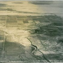
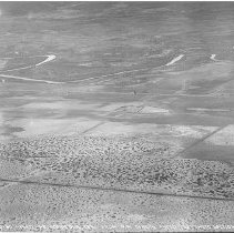
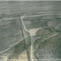
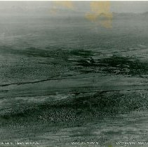
1900.03.01-19 - Print, Photographic
(Documentary Artifact) One photograph, black and white, shot from an aerial perspective. The photograph depicts a landscape with roads, a river, and farm land. The bottom of the photograph reads, "36 Irrigation W. of El Centro, Cal. Official Photo 22nd Photo Section."
Record Type: Photo
-
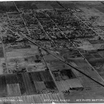
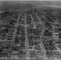
1900.03.01-20 - Print, Photographic
(Documentary Artifact) One photograph, black and white, shot from an aerial perspective. The photograph depicts a highly populated landscape with roads, houses, buildings, and farm land. The bottom of the photograph reads, "37 El Centro, Cal. Official Photo 22nd Photo Section."
Record Type: Photo
-
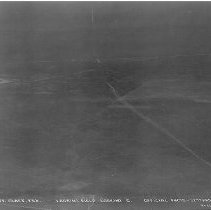
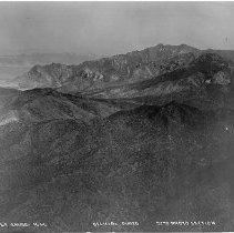
1900.03.01-21 - Print, Photographic
(Documentary Artifact) One photograph, black and white, shot from an aerial perspective. The photograph depicts a desert landscape with a few buildings, mountains, and roads. The bottom of the photograph reads, "46 Cochise, Ariz. from S.E. Official Photo 22nd Photo Section."
Record Type: Photo
-
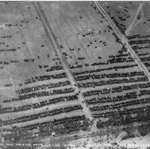
1900.03.01-22 - Print, Photographic
(Documentary Artifact) One photograph, black and white, shot from an aerial perspective. The photograph depicts a landscape filled with parked cars with roads are also visible. The bottom of the photograph reads, "11 Crowd and Parking area, C.F. Cal 3-16-24 Official Photo 22nd Photo Section A.S." C.F. stands for Clover Field which is the present day Santa Monica Airport (see notes).
Record Type: Photo
-
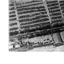
1900.03.01-23 - Print, Photographic
(Documentary Artifact) One photograph, black and white, shot from an aerial perspective. The photograph depicts a landscape with two large structures, numerous parked cars, and many people waiting in a line. The bottom of the photograph reads, "15 Crowd and Parking, Clover Field 3-16-24 Official Photo 22nd Photo Section."
Record Type: Photo
-
1900.03.01-24 - Print, Photographic
(Documentary Artifact) One photograph, black and white, shot from an aerial perspective. The photograph depicts a landscape with mountains, roads, and buildings. One structure is round, possibly a water tank or silo. The bottom of the photograph reads, "No 38 Sierra Blanca, Tex. From N. Official Photo 22nd Photo Section 3-12-24."
Record Type: Photo
-
1900.03.01-25 - Print, Photographic
(Documentary Artifact) One photograph, black and white, shot from an aerial perspective. The photograph depicts a landscape with mountains and roads. The bottom of the photograph reads, "No 41 Landing Field, Ft. Handcock, Tex from N.W. Official Photo 22nd Photo Section 3-12-24."
Record Type: Photo
-
1900.03.01-26 - Print, Photographic
(Documentary Artifact) One photograph, black and white, shot from an aerial perspective. The photograph depicts a landscape with roads and a river. The bottom of the photograph reads, "43 Landing Field - Ft. Handcock, Tex Official Photo 22nd Photo Section 3-12-24."
Record Type: Photo
-
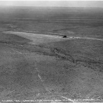
1900.03.01-27 - Print, Photographic
(Documentary Artifact) One photograph, black and white, shot from an aerial perspective. The photograph depicts a landscape with roads and one devloped area. The bottom of the photograph reads, "No 4. Ft. Clark, Tex. Landing Field Looking E. Official Photo 22nd Photo Section 3-11-24."
Record Type: Photo
-
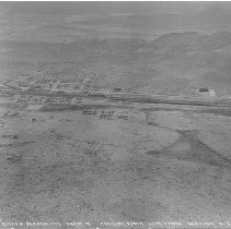
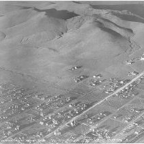
1900.03.01-28 - Print, Photographic
(Documentary Artifact) One photograph, black and white, shot from an aerial perspective. The photograph depicts a landscape with buildings, houses, and roads with a mountain in the distance. The bottom of the photograph reads, "No 22 Alpine Tex. from S. W. Official Photo 22nd Photo Section 3-11-24."
Record Type: Photo
-
1900.03.01-29 - Print, Photographic
(Documentary Artifact) One photograph, black and white, shot from an aerial perspective. The photograph depicts a desert landscape with roads and two buildings. The bottom of the photograph reads, "No 19 Dryden, Tex. Landing Field, Looking N. W. Official Photo 22nd Photo Section 3-11-24."
Record Type: Photo
-
1900.03.01-30 - Print, Photographic
(Documentary Artifact) One photograph, black and white, shot from an aerial perspective. The photograph depicts a desert landscape with roads and two buildings. The bottom of the photograph reads, "No 18 Dryden, Tex Landing Field Looking E. Official Photo 22nd Photo Section 3-11-24."
Record Type: Photo
-
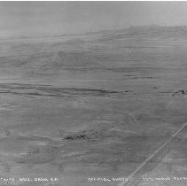
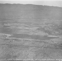
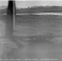
1900.03.01-31 - Print, Photographic
(Documentary Artifact) One photograph, black and white, shot from an aerial perspective. The photograph depicts a desert landscape with roads and mountains. The plane from which the photograph was taken is visible in the photograph. The bottom of the photograph reads, "71 Emerg. Field, Benson, Ariz Official Photo 22nd Photo Section 3-12-24."
Record Type: Photo
-
1900.03.01-32 - Print, Photographic
(Documentary Artifact) One photograph, black and white, shot from an aerial perspective. The photograph depicts a desert landscape with mountains, roads, and rivers. The bottom of the photograph reads, "43 Benson, Ariz. Landing Field Official Photo 22nd Photo Section."
Record Type: Photo
-
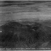
1900.03.01-33 - Print, Photographic
(Documentary Artifact) One photograph, black and white, shot from an aerial perspective. The photograph depicts a landscape with an extinct volcano and some roads in the background. The bottom of the photograph reads, "53A Extinct Volcano W. of Mt Riley, N.M. Official Photo 22nd Photo Section 3-12-24."
Record Type: Photo
-
1900.03.01-34 - Print, Photographic
(Documentary Artifact) One photograph, black and white, shot from an aerial perspective. The photograph depicts a landscape with roads and mountains in the distance. The bottom of the photograph reads, "41 Benson, Ariz Landing Field Official Photo 22nd Photo Section."
Record Type: Photo
-
1900.03.01-35 - Print, Photographic
(Documentary Artifact) One photograph, black and white, shot from an aerial perspective. The photograph depicts a landscape of mountains and trees. The bottom of the photograph reads, "64 Devils Range N.M. Official Photo 22nd Photo Section 3-12-24."
Record Type: Photo
-
1900.03.01-36 - Print, Photographic
(Documentary Artifact) One photograph, black and white, shot from an aerial perspective. The photograph depicts a landscape with mountains, a river, and roads. The bottom of the photograph reads, "50 Emergency Field W. of Mt. Riley Sta. N.M. Official Photo 22nd Photo Section 3-12-24."
Record Type: Photo

-
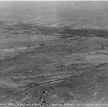
1900.03.01-37 - Print, Photographic
(Documentary Artifact) One photograph, black and white, shot from an aerial perspective. The photograph depicts a landscape of an urban area with businesses, houses, streets, and a train station with trains and tracks. The bottom of the photograph reads, "48 Business Section, El Paso, Tex. Official Photo 22nd Photo Section 3-12-24."
Record Type: Photo
-
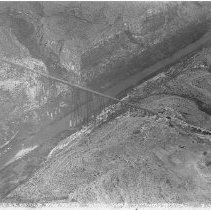
1900.03.01-38 - Print, Photographic
(Documentary Artifact) One photograph, black and white, shot from an aerial perspective. The photograph depicts a landscape with a bridge that spans over a river and a canyon. Some buildings are visible also. The bottom of the photograph reads, "No 10 S.P.R.R. Bridge over Pecos Official Photo 22nd Photo Section 3-11-24."
Record Type: Photo